Excellent paper by Pamela O’Neill from the Journal of the Australian Early Medieval Association.
Reproduced here with the kind permission of the author.
Abstract
The part of Scotland inhabited by the Dalriada1 during the early medieval period is particularly rich in material remains, including a vast corpus of ecclesiastical stone sculpture. In this paper, I examine the cross-marked stones which appear singly in isolated locations throughout Dalriada, and investigate their placement in the landscape. In doing so, I seek to understand the relationship between the ecclesiastical presence in Dalriada and the largely inhospitable landscape of the region. In particular, I consider the purpose of these isolated cross-marked stones, and the reasons for their placement in relation to the landscape and, more importantly, the seascape.
The sea was a constant factor in the lives of all who were connected with Iona. To reach their monastery, Columba and those who followed him had to cross the sea. To travel anywhere from the monastery involved the sea … The sea brought them visitors, guests, books and supplies. It was visible all round them, and its sounds and fury part of their daily lives … they knew ships and sailing intimately and saw the wonders of the sea around them.2
These words, from Thomas O’Loughlin’s ‘Living in the ocean’, go some way towards explaining a phenomenon which I believe that modern scholars of the early medieval British Isles have difficulty understanding, or even conceptualising, despite the fact that it is frequently mentioned. We see land as the place where one lives, works and travels, punctuated from time to time by water, in the form of rivers, lakes and the sea, which we frequently use to signify borders or boundaries of one kind or another. It is my contention that early medieval inhabitants of a significant part of the British Isles had the contrary view: that water was the place where one functioned, travelled and, to a large extent, worked, and that it was punctuated from time to time by land: islands, peninsulas and the like, where one might sleep, build one’s church, graze one’s animals and harvest one’s crops. Borders and boundaries were more frequently formed by the steep impassable mountains which punctuated the larger bodies of land.
This, I believe, is particularly true of Dalriada, the Gaelic-speaking settlement in the west of Scotland in the early medieval period, and even more true for the monastic members of that settlement. There were probably about 20 monasteries spread over island and coastal locations in Dalriada, owing allegiance to, or founded from, a number of different monastic familia in Ireland. There are also a large number of cross-marked stones distributed throughout Dalriada. Many of these are situated alone in relatively isolated locations. In this paper, I want to explore these stones and their locations in relation to landscape features, to suggest a way of interpreting their nature and function.
The sculptured stones of Dalriada come in a variety of shapes, sizes and styles. The most immediately recognisable are the so-called high crosses typified by those on Iona and Islay. There are also large numbers of small simple slabs marked with crosses, which we assume, based on some of their features and their distribution in large clusters at specific sites, are grave markers. This paper will not be discussing either of these groups in any detail. What I wish to discuss are the isolated cross-marked stones that generally occur alone at individual sites.
Most, but not all, of these stones are roughly shaped pillars or slabs, some of them possibly pre-existing standing stones, marked with a simple incised or relief cross. Their size varies considerably. What, I argue, may be a unifying feature of the corpus is the relationship of the stones to the landscape and, perhaps more importantly, to the seascape. It is my belief that in order to fully appreciate the function of these stones we ought to view them, not from the land, but from the water, as I am sure the early medieval communities who used them did.
I begin with a cross-marked slab at Camas nan Geall, on the Ardnamurchan peninsula.3 It is a good starting point, because it is one of those serendipitous sites where the placename is probably as informative as the sculptured stone. Camas nan Geall is a Gaelic place name. Camas is derived from the element Cam-, ‘crooked’, and is generally taken to refer to a bay. Indeed, modern Irish and Scottish Gaelic dictionaries list the word with that meaning, and sometimes also ‘harbour’.4 A variant form, cambus, often refers to a river-bend, although the two forms are occasionally interchangeable, and other variant forms also occur. In the case of Camas nan Geall, camas clearly reflects the topography of the place. W J Watson suggested that nan Geall is a corruption of na gCeall, meaning ‘of the churches’.5 This is a plausible interpretation, particularly in light of the fact that the place contains, in addition to the cross-marked stone, a well named for St Columba, an eighteenth-century burial-ground named for St Ciaran, and a prehistoric chambered cairn.6 However, there is no indication that it has ever contained an actual church, much less more than one church, as Watson’s interpretation seems to imply. Ceall may rather refer to burial grounds, in which case the attribution is unproblematic. It is less likely that the element geall alternatively represents some variation on geal, ‘white, bright’, or geall, ‘pledge’.
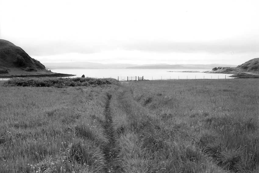
Figure 1: Camas nan Geall, Ardnamurchan (photo: P O’Neill)
The cross-marked stone stands close to the shore in a rounded hollow bounded by steep hills and containing a freshwater well (see figure 1). The hollow encloses a smooth, shallow, and therefore very tidal, beach. The beach itself is contained within a sheltered, rounded bay or cove. Beyond the bay is a narrow stretch of open sea, and beyond that the north end of the island of Mull.
The cross-marked stone at Camas nan Geall is of considerable interest (see figure 2). Badly weathered and, as the photograph shows, rather overgrown, the stone is roughly shaped and stands somewhat more than two metres tall. The side facing the land is unsculpted. The side facing the water bears two apparently fairly plain relief crosses7 and an unidentified animal, which may conceivably be a lion, but might equally well be some other quadruped. That the sculpture faces the bay suggests to me that it is intended to be viewed primarily from the beach, the bay or the sea. The stone is of considerable size and placed at the centre of the hollow, and should be clearly visible from the water. Unfortunately I have not yet had the opportunity to put this theory to the test. However, a further factor should be considered. It is well established that some early medieval stone sculpture was originally painted. Traces of gesso and even of paint have been found on some Anglo-Saxon stone sculpture,8 and it has more recently been suggested that rough tool marks on some early medieval sculpture may have been deliberately left as keying for gesso.9 If the cross-marked stone at Camas nan Geall had originally been painted, it would undoubtedly have been visible from the bay, and almost certainly from the sea beyond.
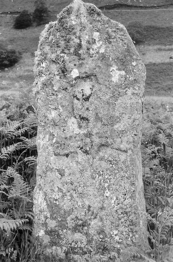
Figure 2: sculptured stone at Camas nan Geall (photo: P O’Neill)
Which brings us to the question of the purpose of this stone. If it was intended to be viewed from the water, as the orientation of the sculpture certainly implies, then I would suggest that its most logical purpose was as some kind of marker. The camas is a sheltered and safe landing place in an otherwise largely inhospitable shoreline. The hollow contains a source of fresh water. It had been visited by people in the distant past, witnessed by the chambered cairn. My suggestion is that the sculptured stone was placed to indicate a suitable place to land, take on water, and possibly set up camp. The presence on the stone of the Christian cross suggests that the signal was intended primarily for the information of Christians, indeed for members of one or more of Dalriada’s monastic communities. We have it on the authority of Columba’s biographer, Adomnán, that Columba himself journeyed to Ardnamurchan sometimes,10 so such a use is not unreasonable.
For what purpose, though, would monastic travellers land at Camas nan Geall? If we assume either a missionary or a pastoral component (or indeed both) to the monastic presence in Dalriada, and such an assumption is certainly justified by Adomnán’s writings, then this is the most likely reason for making land at Camas nan Geall. Indeed, Adomnán describes Columba baptising an infant in Ardnamurchan, after finding himself without water and miraculously creating a spring ‘still to be seen there’ and ‘powerful in the name of St Columba’ in Adomnán’s time.11 Whether or not we choose to believe the details of this account, the description allows the possibility that the scene of this story was Camas nan Geall itself, where the well named for St Columba may be the same spring described by Adomnán. So if members of Dalriadan monasteries were carrying out pastoral or missionary activity in Ardnamurchan, the cross-marked stone at Camas nan Geall may have marked one of the sites where such activity took place. It may therefore have served the dual purpose of showing the water- borne monastic traveller where to land, and showing the residents of the immediate area where to assemble to meet him.
The next site I wish to discuss is Kilmory, on the north coast of the island of Rum (see figure 3). The name is again Gaelic, meaning the church or holy site of Maelrubha.12 Maelrubha belonged to the monastic site at Applecross on the Scottish mainland opposite the island of Skye. Before the highland clearances, Kilmory accommodated a small village, whose burial ground remains clearly visible. Rum is a very mountainous and mostly inhospitable island, except for a few small areas near relatively sheltered bays. At Kilmory, the Kilmory River, named for the site, flows into the sea at one of these sandy bays. Like Camas nan Geall, Kilmory is ringed by large stony mountains.
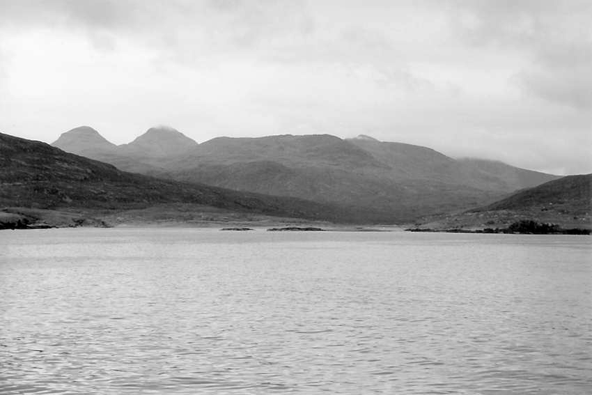
Figure 3: Kilmory, Rum (photo: P O’Neill)
The cross-marked stone at Kilmory is a roughly shaped pillar about 1.7m high. It is no longer in situ, so we cannot establish its original orientation, but it is thought that it originally stood on a small mound near the burial ground.13 One face of the pillar bears a relief cross in a circle on a pedestal, with a smaller latin cross above. This in some ways echoes the stone at Camas nan Geall, where a smaller, simpler cross surmounts a more complex cross, although at Kilmory there is no animal present. I would suggest that this face of the pillar probably faced the sea when the pillar was in situ. The reverse face bears a small sunken latin cross.
This series of three crosses presents obvious dating difficulties. There is nothing to suggest either a reasonably precise absolute date for any of the three, or a relative chronology for them: that is, whether they were made at the same time, or at separate times and in what order. We have neither documentary nor material evidence for an early medieval ecclesiastical foundation on Rum.14 The Annals of Ulster inform us that a hermit named Beccán, who lived on Rum, died in 677.15 It is believed that Beccán had been associated with Columba’s monastery on Iona before taking up solitary residence on Rum.16 Considerable ecclesiastical interest in the Small Isles, of which Rum is one, is attested by the material remains of two foundations on Canna, and the documentary and material evidence of one on Eigg. The cross-marked stone at Kilmory suggests that this site, like that at Camas nan Geall, was visited regularly by members of a monastic community. The stone might again have served the useful dual purposes of guiding a monastic traveller to a safe landing place with fresh water, and showing residents of the area where to meet him.
Kilnave, on the island of Islay, has a single free-standing cross adjacent to a later chapel and burial ground. The first element of the placename derives from cill- (church or holy place). For the second element, Watson suggests Néimh, from St Ném,17 and less likely possibilities are a derivation from nemeton (assembly site) or from naomh (saint). Kilnave is situated on the Rhinns of Islay, on the sheltered shore of Loch Gruinart (see figure 4). The loch is very tidal, and the shore adjacent to Kilnave is mostly smooth and sandy, providing an ideal landing place. The Rhinns of Islay do not have a great deal of high ground and the surrounding area is not so inhospitable as at Kilmory or Camas nan Geall, but the utility of this sheltered landing place is nonetheless clear.
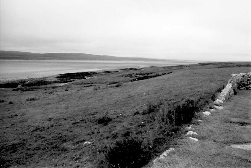
Figure 4: Kilnave, Islay (photo: P O’Neill)
The free-standing cross is made from local flagstone, which has weathered considerably and broken along the natural grain of the stone. It is almost three metres tall as it currently stands.18 The east face of the cross, which faces towards the water, is decorated with elaborate spiral and fret patterns (see figure 5a). The west face is undecorated (see figure 5b). Kilnave shows no evidence of early medieval remains other than this cross. Elsewhere on Islay, Kildalton was probably the site of a monastic foundation, evidenced by the presence of a fully sculptured high cross and several small cross-marked slabs.19 The presence and orientation of the free-standing cross at Kilnave suggest strongly that it marked a site for ecclesiastical visitors in the same way that I have proposed for Camas nan Geall and Kilmory.
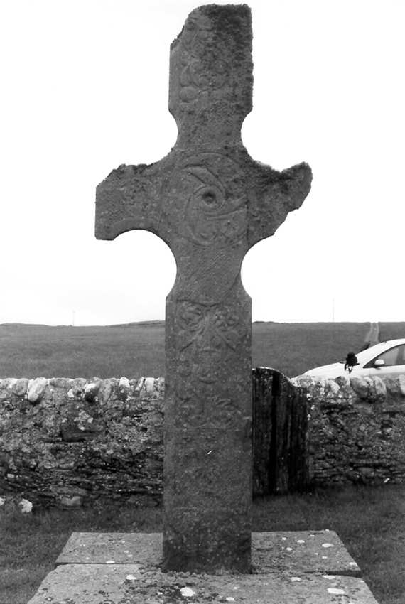
Figure 5a: sculptured stone at Kilnave, east face (photo: P O’Neill)
At Killean, on the west coast of the Kintyre peninsula, an incomplete sculptured stone has been moved into the vault of the MacDonalds of Largie in the burial ground, which is at the site of a late medieval church (see figure 6). The original location of the stone is unknown, but it is likely to have been in or near the burial ground. Indeed, in each of the cases I have so far considered, it is likely that the later burial grounds have accrued to the sites because of the presence of the earlier sculptured stones and the associated assumption of holiness of the sites. Beside the burial ground at Killean, a small stream flows to the sea. The ground of the western side of Kintyre is more low-lying than Ardnamurchan or Rum, and so Killean is not ringed in by mountains, although the inhospitable high ground of central and eastern Kintyre is close by. The stream meets the sea opposite the passage between the islands of Gigha and Cara, some five kilometres offshore. It is therefore easily located and accessed, as well as being reasonably sheltered. The shore is sandy and safe for landing.
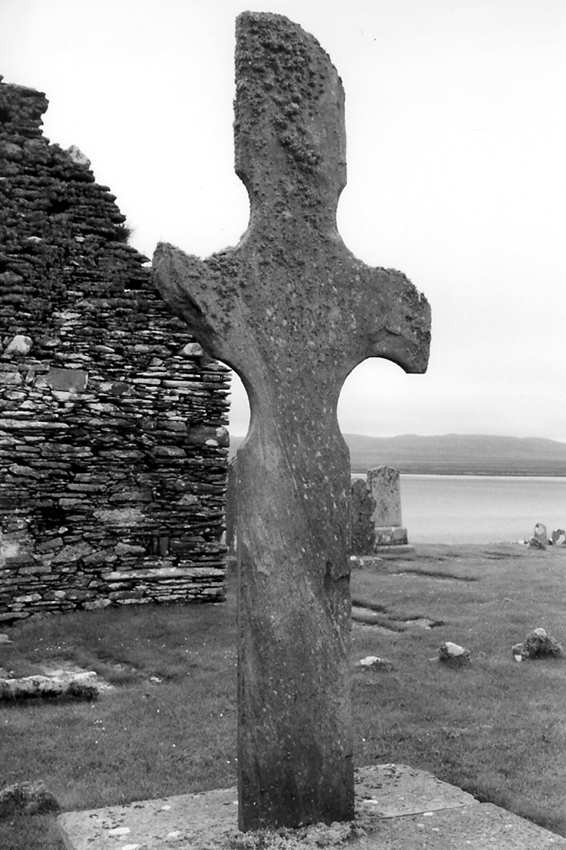
Figure 5b: sculptured stone at Kilnave, west face (photo: P O’Neill)
The cross-marked stone at Killean is incomplete, and its original form cannot be discerned from what remains. The Royal Commission on the Ancient Monuments of Scotland proposed a reconstruction as a free- standing cross.20 It has not been suggested that any sculpture was originally present apart from the outline cross shape on one face, but the possibility cannot be eliminated. The surviving portion of the stone is over 1.8m high.
Clearly a similar function to that of the cross-marked stones at Camas nan Geall, Kilmory and Kilnave is possible.

Figure 6: Killean, Kintyre (photo: P O’Neill)
The region of St Colmac, on the island of Bute, is the site of a now defunct modern church. It is an extremely low-lying area of ground occupying a narrow isthmus between Kames Bay on the east coast and the shallow, sandy Ettrick Bay on the west coast. These isthmuses occur frequently throughout Dalriada, and in Gaelic are called tairbeart. The word occurs in many placenames throughout Dalriada, and frequently refers not only to an isthmus, but to one with this low-lying, sometimes flood- prone character. I would suggest that a tairbeart offers not only the sort of safe landing area which I have been describing, but also a safe and easy portage for carrying boats overland. Such alternative routes would be particularly valuable in territory like Dalriada, where the currents can be particularly dangerous, and most stretches of water are clearly visible from land, enabling surveillance by potentially hostile onlookers.
The cross-marked stone at St Colmac is situated on the west coast of Bute, adjacent to Ettrick Bay. It is a damaged slab, originally with a rounded or pointed head, standing almost 1.5m high.21 The west face, that which faces the bay, is marked with a relief equal-armed cross within a circle, with a spiral-decorated central boss and an incised shaft. Romilly Allen suggested that the arms of the cross were originally decorated, although little of this survives.22 The east face is unsculpted. Here again, the stone’s sculptured side is clearly aligned facing towards the safe landing place of the bay, where it is probably visible from the water. As at Camas nan Geall, the alignment of the stone is compatible with its use as a marker to indicate a safe landing place, and a convenient place for a monastic traveller to minister to the inhabitants of the region.
The site of Tarbert (from tairbeart), on the island of Jura, is another isthmus site, not altogether unlike St Colmac. Here, though, the isthmus is formed by the long indentation of Loch Tarbert from the west coast of the island (see figure 7), and a relatively small bay on the east coast. The tairbeart is again low-lying, and would have formed a perfect and conveniently short portage between the Sounds of Islay and Jura. Such a route may have been highly desirable, because the Sound of Islay is extremely narrow – the modern ferry takes less than five minutes to cross – and the Sound of Jura at its northern end meets the Coire Bhreacan, a large and dangerous whirlpool surrounded by legends and known to adventure- seeking divers. The site contains a later chapel dedicated to St Columba.23
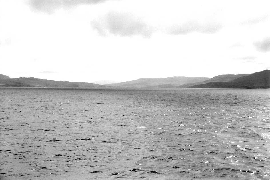
Figure 7: Loch Tarbert, Jura (photo: P O’Neill)
The cross-marked stone at Tarbert differs from my other examples in that it bears almost identical sunken crosses on its opposite faces. It stands almost two metres tall, and is in the form of a pillar.24 It may be a pre-existing standing stone, appropriated for the Christian markings. It is sited on the low-lying ground, within site of Loch Tarbert. However, the fact that it has cross-markings on two faces suggests that it was not intended as a marker or sign viewed only from Loch Tarbert, unlike the others I have discussed which seem to have been meant to be viewed only from the bays they face. I suspect that the cross-marked stone at Tarbert may also have been visible from the east coast, but I have not tested this idea. Certainly, it seems that it was intended as a marker or sign for viewers approaching from either direction. I would suggest that it indicated a portage route, signalling, both to those still at sea and to those crossing the island, the location of the beach. This is no way precludes its use in the ways I have described for the other stones I have discussed. Indeed, such a multiplicity of uses and meanings is, I think, fundamental to our reading of early medieval cross-marked stones.
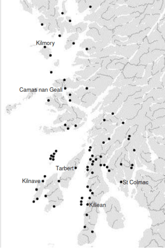
Figure 8: map showing locations of single cross-marked stones
I identify 65 cross-marked stones within Dalriadan territory, excluding those which I believe are likely to be directly associated with monasteries.25 A further eight cross-marked stones are in territory which might have been associated with Dalriadan ecclesiastics, in Knoydart, Skye and Loch Kishorn.26 Of the total of 73 cross-marked stones, 60 are in locations where they might possibly serve the purposes I have outlined (see figure 8).27 Four more meet the same description, but are on the shores of inland lochs rather than the sea or sea lochs. Two have definitely been removed from their original locations, which cannot be identified. There remain only seven cross-marked stones whose locations do not fit the model I have suggested. Most of these are on high ground, although at least one is on an inland waterway. I do not suggest that 66 of the cross-marked stones were created for the sole purpose of marking safe landing places. However, what I do suggest is that this seems to have been a significant use to which many such stones were put.
An interesting light may be cast on the use of cross-marked stones as markers by a term from early Irish law, muirchrech. The precise meaning of muirchrech has not been agreed, but it seems to indicate a measure of distance. It is used to denote the distance out to sea at which the punishment of setting adrift is to occur, in such tracts as Cáin Adamnáin.28 The gloss on the word in Cáin Adamnáin suggests that it is ‘as far out to sea as a white shield will be visible on land’ (in airet [is leir] for muir [sciath] gel for [tir]).29 The word sciath (shield) can also have the more general sense of ‘protection’, and I would suggest that it might appropriately be applied to the apotropaic property of an incised cross. It seems not unreasonable to suppose that the sciath gel, (white shield), of the gloss might represent a painted cross-marked stone.30 Thus a muirchrech would be the distance from which a cross-marked stone at a landing place could be seen from out at sea. Further evidence that a muirchrech was able to be observed by a person at sea is found in Scéla Cano meic Gartnáin, where ‘it apparently stands for the distance out at sea beyond which the departing envoys would cease to enjoy the protection of the kings to whom they had been sent’.31 T F O’Rahilly suggested that the element crech is closely related to críoch, ‘a cutting in the sod, which served as a boundary mark’. He further related crech to the verb creachaim, to ‘mark (originally by an incision)’.32 This idea of marking by incision may relate to the creation of a cross-marked stone, and may be the reason for the inclusion of the element crech in the name of this measure of distance. It is of particular interest that the penalty of setting adrift, and thus perhaps also the term muirchrech, was introduced by ecclesiastics.33 In such a context, it is all the more possible that the distance measure might refer to the visibility of a cross-marked stone.
Causing a cross-marked stone to be erected was presumably an act with several interrelated meanings and purposes. The monument could be many things to many people, just as a modern stained glass window, statue or cross can be. I am sure that many of the stones, as well as serving the maritime purpose I propose, also served as points of assembly, foci of worship and aids to meditation. I do not rule out the possibility that they served as a locus for prayer, probably sometimes in thanksgiving for delivery from the ‘sound and fury’ of that very sea which was the centre of life. When seeking to ‘read’ the cross-marked stones of Dalriada, there is value in trying to put ourselves in the shoes or, I would argue more importantly, in the coracles and sailing vessels of the early medieval monastic. We may thus gain an added dimension to our understanding of early medieval monuments, their distribution and purpose.
References:
1. I use the spelling Dalriada to distinguish the Gaelic-speaking inhabitants of early medieval western Scotland from Dál Riata, denoting a people of northern Ireland.
2. T O’Loughlin, ‘Living in the ocean’ 11-23 in C Bourke (ed), Studies in the Cult of Saint Columba (Dublin, 1997) at p 11.
3. I Fisher, Early Medieval Sculpture in the West Highlands and Islands (Edinburgh, 2001) 123.
4. Eg Geddes and Grosset Gaelic-English English-Gaelic Dictionary (New Lanark, 2004), An Gúm Foclóir Póca (Baile Átha Cliath, 2004).
5. W J Watson, The Celtic Placenames of Scotland (1926; repr Edinburgh, 2004) 514.
6. Fisher, 123.
7. That is to say, the crosses do not now bear any trace of ornament, other than incised crosslets and circular pellets. It is possible that the weathering to the stone has obliterated features that were previously present.
8. Eg D Tweddle, M Biddle and B Kjolbye-Biddle, Corpus of Anglo-Saxon Stone Sculpture Volume 4: South-east England (Oxford, 1995) 44; R Cramp, Corpus of Anglo-Saxon Stone Sculpture Volume 1: Durham and Northumberland (Oxford, 1984) 13.
9. John Blair (University of Oxford), From Marseilles to Morecambe Bay? Stone Coffins and Grave-Linings in Late Anglo-Saxon England (conference paper, International Medieval Congress, Leeds, 2005).
10. Adomnán of Iona, Life of St Columba trans R Sharpe (London, 1995) 121 (I:12), 162 (II:10), 171 (II:22).
11. Adomnán, 162 (II:10).
12. Fisher, 95.
13. Fisher, 95.
14. There are, however, a further cross-marked stone from the south of the island, whose context does not suggest a foundation, although it may indicate hermit occupation (possibly by Beccán), and the Scandinavian placename Papadil (‘valley of priests’), also in the south of the island, which suggests an ecclesiastical association in the Scandinavian period: Fisher, 94-95.
15. The Annals of Ulster (to AD 1131) ed S Mac Airt and G Mac Niocaill (Dublin, 1983) 145.
16. T O Clancy and G Márkus, Iona: the earliest poetry of a Celtic monastery
(Edinburgh, 1995) 12, 129-163.
17. Watson, 307.
18. Fisher, 139, indicates that it has a butt 0.72m long.
19. Fisher, 138-139. It is believed that the distribution of the distinctive high cross is ‘predominantly monastic’ in both Ireland and western Scotland: Fisher, 15.
20. Fisher, 47.
21. Fisher, 81-82.
22. J R Allen and J Anderson, Early Christian Monuments of Scotland (1903; repr Balgavies, 1999) 411-412.
23. Fisher, 136.
24. Fisher, 136.
25. For the purposes of this exercise, I assign a monastic context to the sculptured stones on the islands of Sanda, Inchmarnock, Eilean Mor, Eileach an Naoimh, Iona, Lismore, Tiree, Eigg and Canna, and at the sites of Kingarth (Bute); Kildalton (Islay); Kilmory, Ellary, Keills and Achadh na Cille (Knapdale); Kilmartin and Applecross.
26. I have not investigated sites further north than Loch Torridon.
27. I have not inspected all of the stones and their locations personally, so these numbers are partially based on reported descriptions and study of maps.
28. M E Byrne, ‘On the punishment of sending adrift’, Ériu 11 (1932) 97-102, at p 98.
29. C Plummer apud Byrne, 98.
30. I am grateful to Neil McLeod for drawing this possibility to my attention.
31. D A Binchy, ‘The saga of Fergus mac Léti’, Ériu 16 (1952), 33-48, at p 40. Presumably, for the envoys to enjoy protection within a muirchrech, seafarers must have been able to discern clearly when they drew within that distance – for example, by sighting a marker on the shore.
32. T F O’Rahilly, ‘creach. gad. brad. slad.’, Ériu 13 (1942) 168-170, at p 168.
33. Byrne, 100.

